Windows software for offshore survey
Tools built for people on shift.
Read, reformat and test the serial and UDP strings your survey systems depend on, and turn CTD and SVX2 casts into finished sound velocity profiles, draw vessel and ROV outlines for your navigation display, and work out spool metrology from start to report, with a free survey calculator for the everyday sums and conversions. Each program is a single .exe that runs without installing anything.

THE SHAPE BUILDER
Vessel, ROV and subsea equipment outlines in metres around the CRP, saved as .shp files.
Read more →THE STRINGINATOR
View, filter and reformat serial and UDP strings, and pass them on to other systems.
Read more →
THE SV PROFILER
Valeport CTD and SVX2 casts processed into a report graph and a .usr profile file.
Read more →
THE METROLOGIST
Guided spool and jumper metrology from level loops to hub attitude, with a PDF report.
Read more → FREE
FREE
THE SURVEY CALCULATOR
Positions in any format, UTM, range and bearing, offsets, KP and DCC, units, sound velocity and GPS time.
Read more → FREE
FREE
STRINGINATOR GENERATOR
Simulated vessel, ROV and multibeam data for testing survey systems before the real sensors are online.
Read more →Vessel & ROV shapes · .shp · DXF
The Shape Builder
Draw the outline your navigation display shows for a vessel, ROV or piece of subsea equipment, in metres around the CRP, and save it as a .shp shape file.
- Draw on a metre grid with snap, or type and paste X / Y points straight from Excel.
- Ready-made templates: vessel hull, ROV, TMS, clump weight, circles, rectangles, arrows and a CRP marker.
- Forward arrow tool to show each shape's heading, and Set CRP to put the reference point exactly where it belongs.
- Trace a GA drawing: load an image, scale it from a known dimension and draw over it.
- Simplify large drawings converted from CAD: a 1.4 MB vessel file came down to 315 KB with no visible change.
- Opens and saves .shp and DXF files, and saves projects to carry on later.
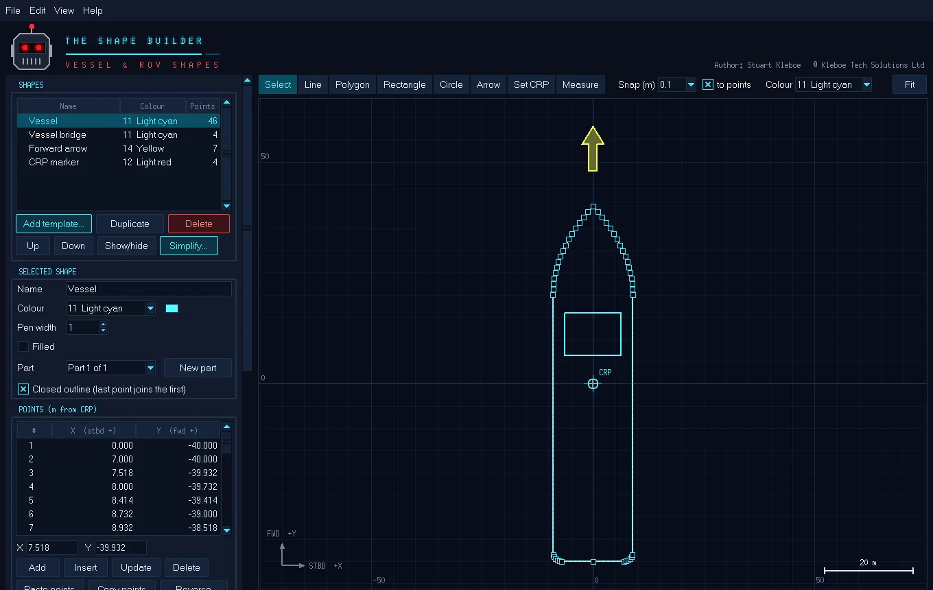
A vessel made from the hull template, with a forward arrow and a CRP marker.
Serial & UDP · Viewer · Formatter
The Stringinator
See exactly what every sensor is sending, pick out the fields you care about, and pass a clean, reformatted string on to the next system.
- Viewer with up to six fields per string, each turning red when its data goes stale.
- Output Formatter: build a new string from fields of an incoming one and send it on serial or UDP.
- Line filtering to pick one string out of a port sending several, by prefix such as
$GPGGA. - Text and binary inputs decoded into readable values.
- Input and Output Display tabs showing every port at once.
- Projects save your whole port setup so it loads in one click next time.
Sound velocity · CTD · SVX2
The SV Profiler
Open a Valeport cast and get a finished profile: downcast and upcast found automatically, a report-ready graph and a .usr profile file in a couple of clicks.
- Mean column SV, mean seabed SV, mean column density and seabed temperature worked out for you.
- Downcast, upcast or both, averaged into the depth step you choose.
- Project name, easting and northing and the instrument serial number on the graph, exported as PDF or PNG.
- .usr and CSV export of the processed profile at 1 m steps.
- Compare two profiles, or run an instrument calibration check with PASS / FAIL against your tolerances.
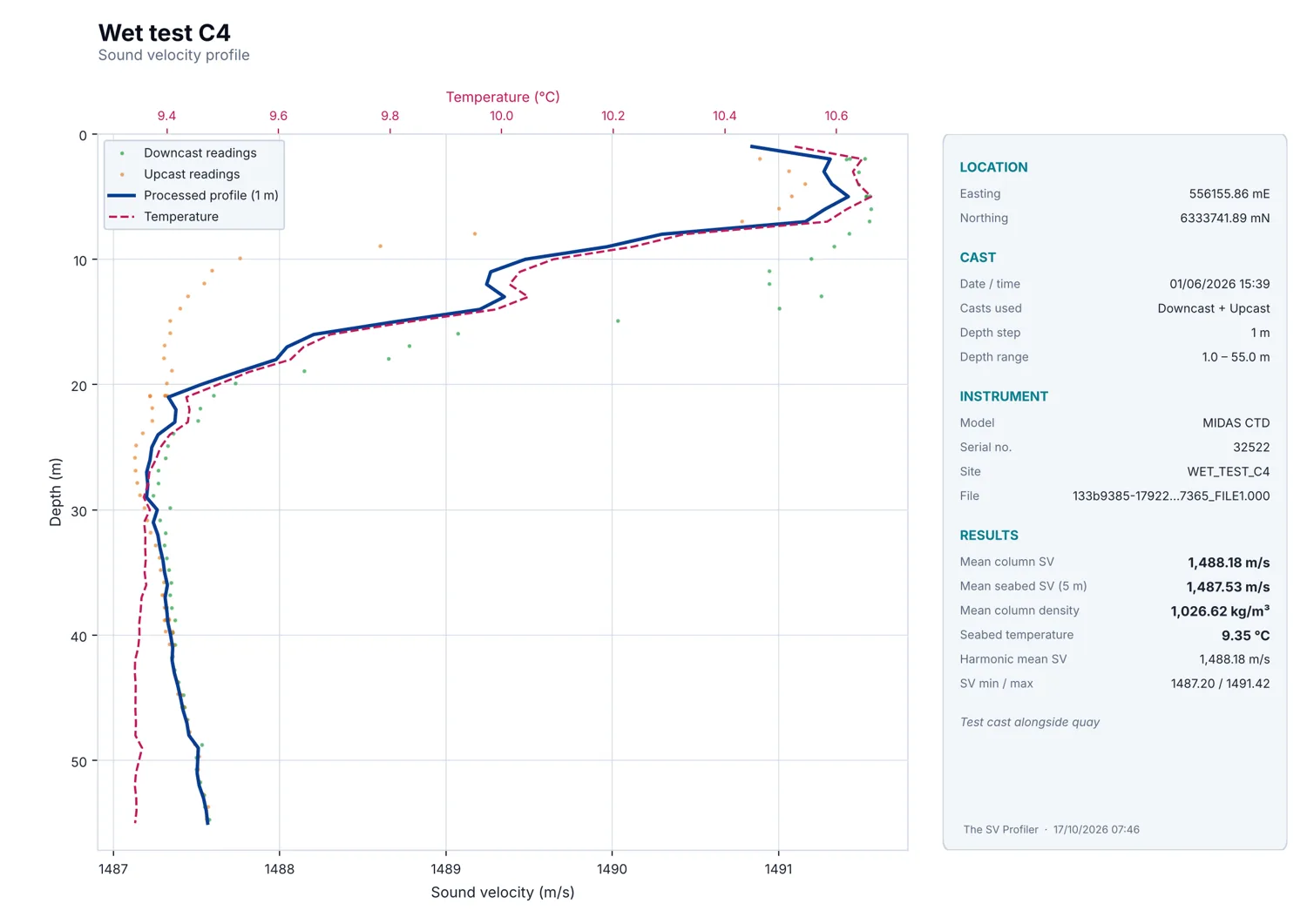
A processed MIDAS CTD cast, both casts at 1 m steps, as exported to PDF.
Spool metrology · LBL · DQZ · Gyro
The Metrologist
Guided subsea spool and jumper metrology: work through the task plan step by step and get the hub-to-hub distance, ΔZ, headings, α / β and hub attitude, with a finished PDF report.
- DQZ level loops with misclosure spread by time, loops tied to one benchmark, and the seabed profile along the route.
- Hub headings and pitch / roll from dockings at any rotation (0 / 90 / 180 / 270 or towards / away), so sensor offsets cancel.
- Direct ranges reduced to horizontal as an independent check on the LBL distance.
- PASS / FAIL checks against your task plan limits, design values and an estimated error budget.
- Import logged data from DQZ, gyro and range logs, paste from Excel, or type the averages.
- PDF report with plan view, seabed profile, every table and a sign-off box.
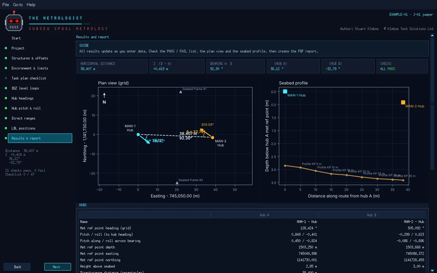
Results: distance, ΔZ, bearing, α and β, with the plan view and seabed profile (example data).
Free · Conversions · Geodesy · Offshore
The Survey Calculator
The everyday sums and conversions of offshore survey in one place. Results update as you type, every answer has a Copy button, and everything you type is remembered for next time.
- Paste a position in any format: decimal degrees, degrees and minutes, degrees minutes seconds, NMEA or a whole GGA / RMC line. It works out the format and shows every other one, plus UTM with grid convergence and scale factor.
- Range and bearing with ΔE, ΔN and ΔZ between two grid points, a point from a range and bearing, and geodesic and rhumb line distances between two lat / longs.
- Vessel offsets to grid and back, and KP and DCC along a route line.
- Units: knots to m/s, km/h and mph with the Beaufort scale, plus distance, pressure, angle, volume, mass and temperature.
- Ocean: sound velocity (UNESCO, Del Grosso, Mackenzie), depth from pressure, towfish layback and acoustic travel time.
- GPS week and seconds to UTC, day of year, and a calculator that works in degrees.
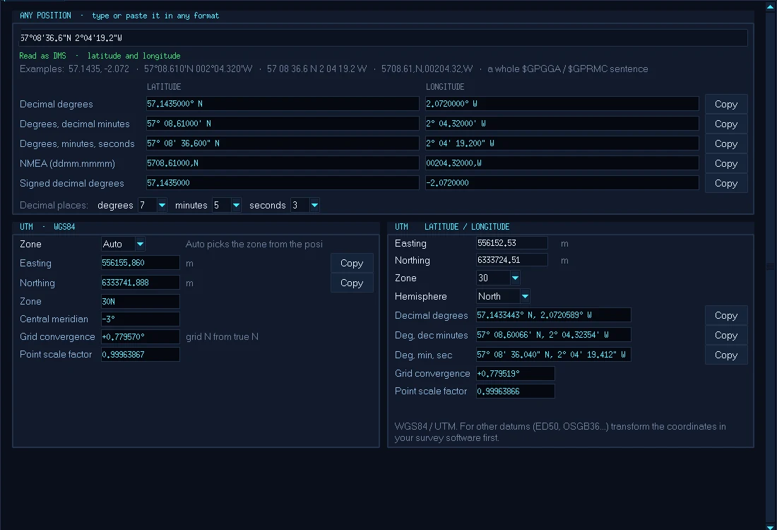
A position typed in degrees, minutes and seconds, shown in every format and in UTM.
Test strings · Vessel · ROV · Multibeam
The Stringinator Generator
Drive a simulated vessel and ROV and send realistic, correctly checksummed strings and R2Sonic multibeam data to your survey, DP or navigation software before mobilisation or while a sensor is down.
- Vessel and ROV tabs with position, heading, speed, turn and motion you set and adjust live.
- GNSS, heading, motion, depth and speed strings, plus ROV gyro, position and DVL.
- R2Sonic multibeam on the vessel hull or the ROV, pinging a made-up seabed with sand waves, a pipeline, boulders and a wreck. Sends BTH0 packets over UDP, with a live swath, a coverage map and XYZ export.
- Several outputs, each on its own serial port or UDP address with its own strings and rates up to 100 Hz.
- Works with The Stringinator for a complete test bench on one PC.
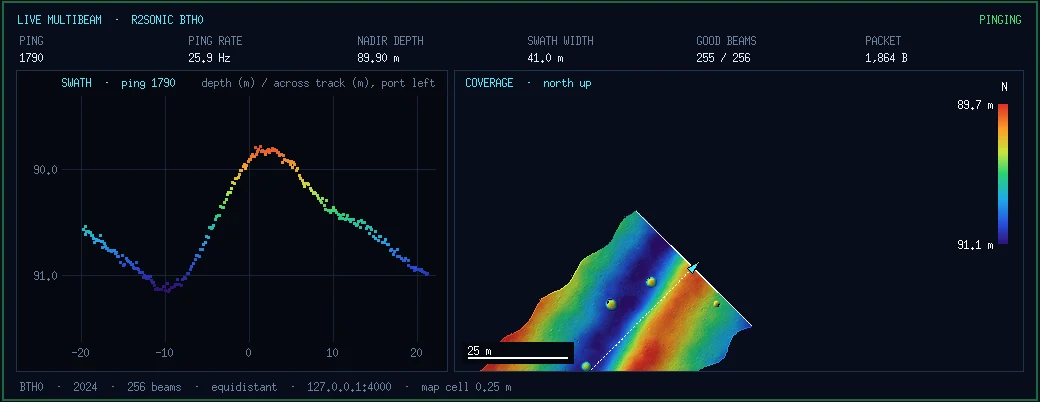
Multibeam on the ROV, 10 m above the seabed: the swath on the left, the pipeline, boulders and sand waves building up on the right.
Licences
Pricing
The Survey Calculator and The Stringinator Generator are free. The Shape Builder, The Stringinator, The SV Profiler and The Metrologist are one licence per PC, with free updates. Each download includes the PDF user manual.
THE STRINGINATOR
- Viewer and Output Formatter
- Input and Output Display
- Saved projects
THE METROLOGIST
- Level loops, headings, pitch / roll
- Direct ranges and LBL
- PDF report
THE SURVEY CALCULATOR
- Positions in any format and UTM
- Range, bearing, offsets, KP and DCC
- Units, Beaufort, sound velocity
- GPS time and a calculator
STRINGINATOR GENERATOR
- Vessel and ROV simulation
- 34 string types
- R2Sonic multibeam (BTH0)
- Serial and UDP outputs
SURVEY BUNDLE
- Shape Builder, Stringinator, SV Profiler and Metrologist
- One licence per PC
- Team licences on request
Draft: prices and checkout links to be added.
Questions
FAQ
What do I need to run the software?
A Windows 10 or 11 PC. Each program is a single .exe: copy it to the PC and double-click. Nothing else needs to be installed, and no internet connection is needed to use it.
Will it work with my serial ports and USB adapters?
Yes. The Stringinator and the Generator use any COM port Windows can see, including USB-to-serial adapters and network serial servers, as well as UDP.
Which sound velocity instruments does The SV Profiler read?
Valeport MIDAS CTD and MIDAS SVX2 files, and most other instruments that save a text file with depth and sound velocity columns.
Which navigation software can use The Shape Builder's files?
It saves .shp shape files (text, in metres from the CRP) and DXF drawings, and opens the same. The user manual describes the .shp layout, so you can check it against your navigation package.
What does The Metrologist need from the survey?
DQZ level loop readings, gyro headings and inclinometer pitch / roll in the hub receptacles, direct ranges between the hub COMPATTs and the calibrated LBL positions. It reads logged text files, pasted columns or typed averages.
Which datum does The Survey Calculator use?
WGS84, with UTM for grid coordinates. For other datums such as ED50 or OSGB36, transform the coordinates in your survey software first.
Can I try before I buy?
The Survey Calculator and The Stringinator Generator are free to download and use. For the other programs, each user manual is free to download from this page, so you can see exactly what the program does.
Do you offer licences for a whole vessel or company?
Yes. Get in touch with the number of PCs and we'll send a quote.
Contact
Get in touch
Questions, quotes for team licences, or a string format you'd like added: send an email and we'll reply within one working day.
Kleboe Tech Solutions Ltd · United Kingdom